Trail Walking Les Cammazes - Le lac des Cammazes - Photo

Le lac des Cammazes

 tracegps
tracegps

User

© OpenStreetMap contributors
Length
Length
15.7 km
Max alt
Max alt
682 m
Uphill gradient
Uphill gradient
435 m
Km-Effort
Km-Effort  
22 km
Min alt
Min alt
501 m
Downhill gradient
Downhill gradient
438 m
Boucle
Boucle
Yes
Creation date :
2014-12-10 00:00:00.0
Updated on :
2014-12-10 00:00:00.0

(1 Reviews)

Walking
Walking
6h00
Difficulty : Medium

Scan this QR Code to open this trail in the SityTrail application

FREE GPS app for hiking

Logo SityTrail SityTrail

IGN / Geographical institutes

Download SityTrail from the App Store Download SityTrail from Google Play

Logo SityTrail SityTrail World

The world is yours!

Download SityTrail from the App Store Download SityTrail from Google Play Download SityTrail on Huawei AppGallery

About

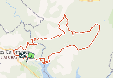
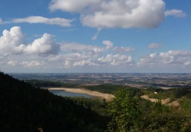
Trail Walking of 15.7 km to be discovered at Occitania, Tarn, Les Cammazes. This trail is proposed by tracegps.

Description

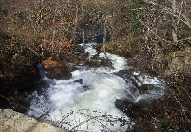
Le lac des Cammazes est un circuit de 15km sans difficultés particulières. Sur la D629 tourner à droite en direction du lac. Le parking est à 100m sur la droite. On suit la route qui serpente jusqu'au pied du barrage puis on s'engage sur le sentier à gauche pour grimper aux abords du lac. Immédiatement à gauche au prend le sentier de «la vallée du Sor». Le circuit est bien fléché et le retour au Cammazes se terminera par le hameau de «En Borrel» à l'ouest du village.

Elevation profile

Photos

Positioning

Country:
France
Region :
Occitania
Department/Province :
Tarn
Municipality :
Les Cammazes
Location:
Unknown
Start:(UTM)
426011 ; 4806437 (31T) N.

Comments

Please log in to post a review or rate the element


mal balisé


Trails nearby

Trail On foot Les Cammazes - 2021-04-25_15h18m40_randonnee-pedestre-aux-cammazes-dans-le-tarn - Photo
On foot
Maxime Dallaston

On foot

Easy
(1)
Les Cammazes, Occitania, Tarn, France
7.3 km | 11 km-effort
2h 29min
Yes
Trail Mountain bike Sorèze - Sorèze - Montagne Noire - Photo
Mountain bike
tracegps

Mountain bike

Very difficult
(1)
Sorèze, Occitania, Tarn, France
36 km | 53 km-effort
3h 30min
Yes
Trail On foot Sorèze - Soreze  Oppidum de Berniquaut en boucle. - Photo
On foot
caccini

On foot

Medium
(1)
Sorèze, Occitania, Tarn, France
16.4 km | 24 km-effort
5h 26min
No
Trail Walking Verdun-en-Lauragais - BDM Du camping au salon puis retour - Photo
Walking
dtrinquelle

Walking

Medium
(1)
Verdun-en-Lauragais, Occitania, Aude, France
13.9 km | 17.7 km-effort
1h 30min
Yes
Trail Mountain bike Sorèze - 2012-04-01cammazes - Photo
Mountain bike
Arpones

Mountain bike

Difficult
(1)
Sorèze, Occitania, Tarn, France
49 km | 63 km-effort
3h 17min
Yes
Trail Walking Les Brunels - Boucle entre le Lac de Saint Ferréol et la Lac des Cammazes - Photo
Walking
tercla

Walking

Difficult
Les Brunels, Occitania, Aude, France
19.8 km | 28 km-effort
4h 58min
Yes
Trail On foot Sorèze - La boucle du Bois Grand - Photo
On foot
PRO

On foot

Easy
Sorèze, Occitania, Tarn, France
7 km | 10.7 km-effort
2h 26min
Yes
Trail Walking Saissac - Cammazes Lampy fait. - Photo
Walking
pidjam

Walking

Easy
(1)
Saissac, Occitania, Aude, France
14.8 km | 17.3 km-effort
4h 36min
Yes
Trail Other activity Les Cammazes - pêche au cammazes broc  - Photo
Other activity
becken

Other activity

Very easy
(1)
Les Cammazes, Occitania, Tarn, France
2.2 km | 2.7 km-effort
2h 56min
No


Close
My subscriptions